


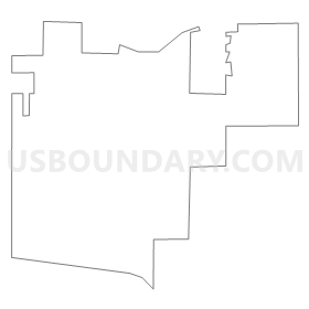
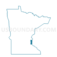
Mahtomedi P-2, Washington County, Minnesota
About
Outline
Summary
| Unique Area Identifier | 604848 |
| Name | Mahtomedi P-2 |
| County | Washington County |
| State | Minnesota |
| Area (square miles) | 2.24 |
| Land Area (square miles) | 2.05 |
| Water Area (square miles) | 0.19 |
| % of Land Area | 91.49 |
| % of Water Area | 8.51 |
| Latitude of the Internal Point | 45.04630410 |
| Longtitude of the Internal Point | -92.96675400 |
Maps


Graphs
Select a template below for downloading or customizing gragh for Mahtomedi P-2, Washington County, Minnesota


Neighbors
Neighoring Voting District (by Name) Neighboring Voting District on the Map
- Birchwood Village City Voting District, Washington County, MN
- Grant Voting District, Washington County, MN
- Mahtomedi P-1, Washington County, MN
- Oakdale P-5, Washington County, MN
- Pine Springs Voting District, Washington County, MN
- White Bear Lake W-4 P-1, Ramsey County, MN
- White Bear Lake W-4 P-2, Washington County, MN
- Willernie Voting District, Washington County, MN
Top 10 Neighboring County Subdivision (by Population) Neighboring County Subdivision on the Map
- Oakdale city, Washington County, MN (27,378)
- White Bear Lake city, Ramsey County, MN (23,394)
- Mahtomedi city, Washington County, MN (7,676)
- Grant city, Washington County, MN (4,096)
- Birchwood Village city, Washington County, MN (870)
- Willernie city, Washington County, MN (507)
- Pine Springs city, Washington County, MN (408)
- White Bear Lake city, Washington County, MN (403)
Top 10 Neighboring Place (by Population) Neighboring Place on the Map
- Oakdale city, MN (27,378)
- White Bear Lake city, MN (23,797)
- Mahtomedi city, MN (7,676)
- Grant city, MN (4,096)
- Birchwood Village city, MN (870)
- Willernie city, MN (507)
- Pine Springs city, MN (408)
Top 10 Neighboring Unified School District (by Population) Neighboring Unified School District on the Map
- North St. Paul-Maplewood School District, MN (76,855)
- White Bear Lake School District, MN (61,182)
- Mahtomedi Public School District, MN (13,690)
Top 10 Neighboring State Legislative District Lower Chamber (by Population) Neighboring State Legislative District Lower Chamber on the Map
- State House District 52B, MN (42,649)
- State House District 55B, MN (38,632)
- State House District 53B, MN (36,398)
Top 10 Neighboring State Legislative District Upper Chamber (by Population) Neighboring State Legislative District Upper Chamber on the Map
- State Senate District 52, MN (90,197)
- State Senate District 55, MN (76,856)
- State Senate District 53, MN (73,997)
Top 10 Neighboring 111th Congressional District (by Population) Neighboring 111th Congressional District on the Map
Top 10 Neighboring Census Tract (by Population) Neighboring Census Tract on the Map
- Census Tract 424.01, Ramsey County, MN (5,767)
- Census Tract 404.02, Ramsey County, MN (5,320)
- Census Tract 403.02, Ramsey County, MN (5,225)
- Census Tract 709.07, Washington County, MN (4,991)
- Census Tract 703.03, Washington County, MN (4,811)
- Census Tract 703.04, Washington County, MN (4,714)
- Census Tract 704.03, Washington County, MN (3,884)
Top 10 Neighboring 5-Digit ZIP Code Tabulation Area (by Population) Neighboring 5-Digit ZIP Code Tabulation Area on the Map
- 55110, MN (37,759)
- 55082, MN (35,024)
- 55109, MN (31,444)
- 55128, MN (28,113)
- 55115, MN (8,607)
- 55090, MN (401)